Whats Hiding Beside This Path?
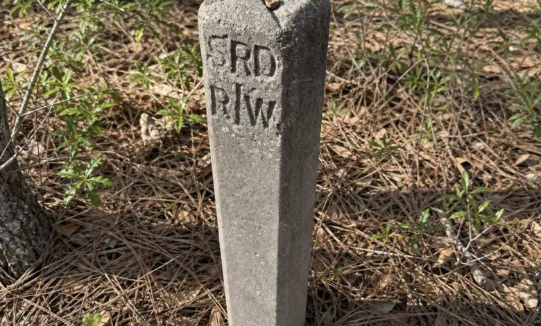
Deep beside an old roadbed in the woods stood a knee-high concrete post. It had no sign attached, no obvious opening, and no decoration. Moss and leaves surrounded it, while the route nearby had almost disappeared into the landscape. The object looked mysterious only because the ordinary world that once explained it was gone.
Concrete posts like this were often installed as right-of-way markers. Letters such as R/W commonly indicated the legal boundary of land reserved for a road, railway, utility corridor, or another public route. Other initials could identify a highway department, railroad, survey district, or local agency responsible for the property.
A right-of-way is wider than the surface people actually travel. It can include shoulders, drainage areas, slopes, ditches, utility space, and room for future maintenance. Surveyors placed durable markers at important points so workers and neighboring landowners could locate the official boundary without relying on a wooden stake that might rot or a painted line that would quickly disappear.
Concrete was ideal for the job. It resisted weather, fire, insects, and accidental damage better than many alternatives. A marker could remain in place for generations after the road stopped receiving maintenance. Trees might grow around it, gravel could sink beneath soil, and maps could be forgotten while the small post continued standing exactly where a survey crew had placed it.
The nearby old roadbed supports that interpretation. Roads leave subtle evidence long after regular traffic ends. The ground may form an unusually level bench across a slope. Stones of similar size may appear in a straight line. Parallel ditches, a raised center, trimmed embankments, or gaps between mature trees can reveal a route hidden beneath leaves.
Railroad grades create similar clues. They tend to maintain gentle curves and gradual slopes because trains cannot handle sudden changes in elevation. Old telegraph insulators, spikes, culverts, bridge abutments, or evenly spaced ties may appear nearby. A concrete marker beside such a grade could identify railroad property rather than a highway boundary.
The stamped letters matter. R/W is widely understood as right of way, while a code such as SRD could refer to a specific state road department or survey authority depending on the region and time period. Initials should be interpreted alongside local maps and records rather than through a universal list, because agencies reused similar abbreviations.
Historical topographic maps, county road books, railroad maps, and property plats can help identify the abandoned route. Comparing older maps with modern satellite imagery often reveals where a road once continued. Local historical societies and transportation departments may recognize the shape of the post or the exact lettering used by a former agency.
The marker should be left in place. Even when it appears abandoned, it may still have legal significance or serve as evidence for a modern survey. Moving it can destroy historical context and create confusion about boundaries. Photographs, measurements, visible inscriptions, and the location can be recorded without disturbing the object.
Once its purpose is understood, the post changes the way the surrounding woods look. A shallow depression becomes a ditch, a line of stones becomes a road edge, and an empty corridor between trees becomes a route people once traveled every day. The concrete marker is not a monument in the grand sense. It is a quiet piece of infrastructure still doing its job, preserving the edge of a path long after the traffic and signs have disappeared.
Anyone documenting a find can photograph each face of the marker, note its direction relative to the old road, and record only a general location when private property or fragile sites are involved. Those observations may help a historian match it to a survey without encouraging damage. The best discoveries often remain where they were found, allowing the landscape and the object to continue telling the same story together.